Sardelli Survey, LLC
Social Media
  • Home
  • Drones
  • About
  • Services
  • Contact

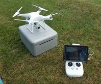
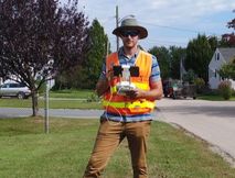
Drone Mapping and Inspection

Sardelli Survey posses the necessary licensing (FAA Part 107) to operate drones in the National airspace. We use the latest software and technology to bring your project to life. Whether you're looking to monitor a site over time, inspect your existing infastructure or just need a more cost effective solution for medium to large scale projects, we've got you covered. Please give us a call or fill out our contact form, if you need additional information about our services.

​Jamie L. Sardelli, PLS
​

Contact Form
Drone Services
  • Mapping (2d/3d planimetrics)
  • Inspection (Utilities/Construction)
  • 3d Model (Point Cloud/mesh)
  • Orthophotography
  • Monitoring (Pre and Post Construction)

Check out the following Links:

$$SPECIAL$$ - Private Flight w/current data (Click here)
*Determining Level of Detail (Click here)
Picture
Picture
Phantom 4 Pro
​(Remote PIC - Jamie L. Sardelli)

Sardelli Survey, LLC
P.O. Box 1017
Charlestown, RI 02813